February 10, 2012 08:21:56 AM
:
elizabeth S. Titus
:
upper West Side/CPW
:
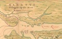
The earliest known map of NYC, the 1639 Manatas Map
:
"This map, possibly done to encourage Dutch settlement, depicts plantations and small farms. These widely dispersed settlements are keyed by number in the lower right-hand corner to a list of land occupants. The list of references includes a grist mill, two sawmills and "Quarters of the Blacks, the Company's Slaves." Also delineated are a few roads represented by dashed lines and four Indian villages situated in what is now Brooklyn."
Library of Congress
:
Leave a Comment
Email addresses are required but never displayed.